I can't beat Lori's fantastic alpine tour but here is my version of rocky affairs at the moment.
The Archipelago of Kragerø, Norway, consists of about 450 islands, many small and some larger (up to about 8 x5 km2). Most of them are covered by pine forest. The area is a popular place for boating with lots of narrow fjords, inlets, beaches etc. Almost all islands have summerhouses and a few have year-round residents. At the southeast coast you get the best summer weather in Norway here.
Two of the islands consist of moraine - sand, pebbles and boulders; and clay underneath. On these islands the flora is richer and it is popular to picnic here. Small roads and paths make it easy to walk around (or bike).
Here are some pics taken today - nice weather but windy so I got soaked, we had to cross open sea to get to the utmost island of Stråholmen. First the small "village" on the island.
(Have to load only 2 pics at the time)
Comments
Re: Not alpine but lot of rocks
The weather can be tough on the utmost islands. Here the juniper has flattened out.
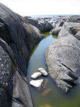
It is a lot of small freshwater ponds here filled by rainstorms.
Re: Not alpine but lot of rocks
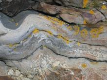
The rock is mineral rich and contains iron ore of high quality but low volume fortunately. The last iron mine closed 50 years ago. More than 100 years ago some people made fortunes digging rare elements like thorium and niobium. One of the Worlds largest thorium deposits is not far away on the mainland.
Re: Not alpine but lot of rocks
Rosa rugosa is common along the shores. It is a garden escape and not all people like that!
Re: Not alpine but lot of rocks
The majority of the plants are rather common but they can still be attractive!
(Coffeetime - a few more in a while)
Re: Not alpine but lot of rocks
Wow, fabulous rock formations and erosion! Love the lichens.
The stone walls are very interesting... they don't look high enough to contain livestock so were they just property divisions or... ?
The last plant you showed - Honkenya peploides - looks wonderful, terrific foliage! It is circumpolar, apparently.
Re. Rosa rugosa, there are a lot worse weeds. ;)
Re: Not alpine but lot of rocks
Wow, fabulous rock formations and erosion! Love the lichens.
The stone walls are very interesting... they don't look high enough to contain livestock so were they just property divisions or... ?
The last plant you showed - Honkenya peploides - looks wonderful, terrific foliage! It is circumpolar, apparently.Re. Rosa rugosa, there are a lot worse weeds. ;)
I think in old times the stone walls were covered by spiny bushes. They were property divisions as well. Families typically had one cow for milk and lived of fish and potatoes.. The husbands were pilots waiting for the ships to arrive.
Honkenya is leaves, the flowers are small and insignificant.
Re: Not alpine but lot of rocks
First coffee then dishwashing (the manual way).
Nice little Sagina nodosa on shallow sandy soil.
Potentilla anserina covers large patches with creeping stems.
Re: Not alpine but lot of rocks
Tiny but handsome Geranium.
Calystegia sepium where it belongs at the seashore.
Re: Not alpine but lot of rocks
Holes in the bedrock made by grinding stones in running water under the cover of ice during the last ice age. These holes can be several meters deep and wide. We call them "jettegryter" = "giants pans". Do you have a word for such holes in English?
Here a bullrush finds enough water even in dry spells in summer.
Re: Not alpine but lot of rocks
Lotus corniculatus is very common. You can find it from the seashore to high up in the mountains.
Seakale smells and tastes - very strongly - as kale. Too late for flowers though.
Re: Not alpine but lot of rocks
Last pictures for this time. Takes time to load these with a cellphone!
Minilakes almost like the fjords.
Re: Not alpine but lot of rocks
Terrific set of photos. What a fascinating area for a coastal hike!
Potentilla anserina cowers large patches with creeping stems.
Another circumpolar one that I haven't seen in a while. Oddly enough, there's a British Columbia plant nursery that sells it, and claims it to be a zone 6 plant! ;D
Tiny but handsome Geranium.
Calystegia sepium where it belongs at the seashore.
Yes, to all comments!
Holes in the bedrock made by grinding stones in running water under the cover of ice during the last ice age. We call them "jettegryter" = "giants pans". Do you have a word for such holes in English?
You know, I think there is likely a word, but I'll be darned if I can come up with one! "Plunge pool" is about the closest I can think of - where rocks are blasted around in a pocket by the force of water, and continue to erode out a chute.
http://en.wikipedia.org/wiki/Plunge_pool
(Water-eroded pockets like that may be called tinaja in the desert southwest U.S., but that's not quite the same... not normally glacially-related, I don't think.)
Nice to see seakale in it's natural habitat. (I grow it but it won't bloom for a while yet.) Same for birdsfoot trefoil (Lotus corniculatus).
Nice tour of the island!
Re: Not alpine but lot of rocks
Holes in the bedrock made by grinding stones in running water under the cover of ice during the last ice age. These holes can be several meters deep and wide. We call them "jettegryter" = "giants pans". Do you have a word for such holes in English?
Here a bullrush finds enough water even in dry spells in summer.
Interesting travels Trond, some of the rock formations are most scenic. Not small holes, but larger ones caused by glaciation, are called "kettle ponds" or "kettle holes", see http://en.wikipedia.org/wiki/Kettle_%28landform%29
I was going to joke that we get these large holes in the road every winter in spring, pot holes, but I guess these kettle holes can be called potholes too, based on the wikipedia link.
Re: Not alpine but lot of rocks
Kettle holes are a little different again... not caused by erosion by rocks and flowing water, but rather, by subsequent melting of a block of ice that became encased in glacial sediments as the glaciers melted back.
Re: Not alpine but lot of rocks
I think Lori is right, Mark, kettleholes is called "kjelehull" (same word) or "dødisgrop (= dead ice pit) in Norwegian. It is a different kind of formation.
It is a fine area for coastal hike but you have to use a boat!
Re: Not alpine but lot of rocks
Just like I have said to Todd, about liking and learning about wild New Foundland by his photos, yours are equally interesting, Trond. All of them!!!
We have a few rock formations in Minnesota that have shallow, ephemeral pools that support fairly rare, and often endangered species of plants and amphibians. Our native Phemeranthus parviflorum(Talinum parviflorum) & Phemeranthus rugospermus(T. rugosum) are among them, although not considered rare. Your pools do seem a lot deeper than ours, and ours are not formed by what almost looks like cracks in the rock in your photos. rather, they are shallow depressions on the rock surfaces.
We call those holes "pothole", geologically speaking. Minnesota boasts the deepest (60ft. x 12-15ft.) and most concentrated number of them in the world. They are in Interstate State Park, only about 100 miles away from me. It's really a cool place to visit, and not just for the potholes.
http://files.dnr.state.mn.us/destinations/state_parks/interstate/interst...
Re: Not alpine but lot of rocks
Thank you, Rick, it's apleasure to show you (albeit timeconsuming with a cellphone!).
Your link is very interesting! I think pothole is the same as Norwegian "jettegryte". The biggest in Norway is 100m deep and 40m wide. The place is called Hell (Helvete)
http://www.fjordnorge.dk/norsk/naturfenomen_no.htm
Re: Not alpine but lot of rocks
100m x 40m, Wow!!! From the description given, your Norwegian potholes are formed the same way ours are. I guess our DNR (Department of Natural Resources) has not done its homework. Minnesota certainly doesn't have the deepest potholes in the world!
Re: Not alpine but lot of rocks
Wonderful photos, Hoy! #23 especially is gorgeous, perfectly framed, and feels so...still.
In eastern US we call the glacial phenomena "pot-holes". I like "giants' pans" better!
Re: Not alpine but lot of rocks
Wonderful photos, Hoy! #23 especially is gorgeous, perfectly framed, and feels so...still.
In eastern US we call the glacial phenomena "pot-holes". I like "giants' pans" better!
Thanks, Jeremy. I can tell you that it is more often than not still, you have the open ocean straight ahead! But I understand what you mean.
Here are a few more - it is thousands of similar and different motifs there.
Re: Not alpine but lot of rocks
The seaside views are just like Newfoundland....many of the plants are the same as well!...however, some of the plants, like Lotus and Lythrum, are considered invasive weeds on this side of the pond!
I don't recall any kettle holes in our area. Very unique.
I can see how the Vikings probably felt at home here when they arrived at L'Anse-aux-Meadows around 1000 years ago.
Re: Not alpine but lot of rocks
Great to see this area, and some lovely plants..the Lotus is also an invader here, not too common in my area--maybe in towns: I sometimes see some yellow things as I pass by in the car, though its not the only choice... I did see one plant in the foothills this summer, I wonder if it will be a whole hillside of them in a few years?
I'm very fond of P anserina-- originally I wasn't sure if it was native or introduced, but I have read its native, so I'd like to get some pieces, there are parts of my 'lawn' that could use it! Much nicer than grass ;D I saw some in a nearby town this year, so I will have to try to get some pieces....


More village....